Showing posts with label PCT. Show all posts

Sunday, September 11, 2011

Red Pass via Commonwealth Basin

Trail Distance: 6.2 miles out and back
Cummulative Elevation Gain: 2500 ft
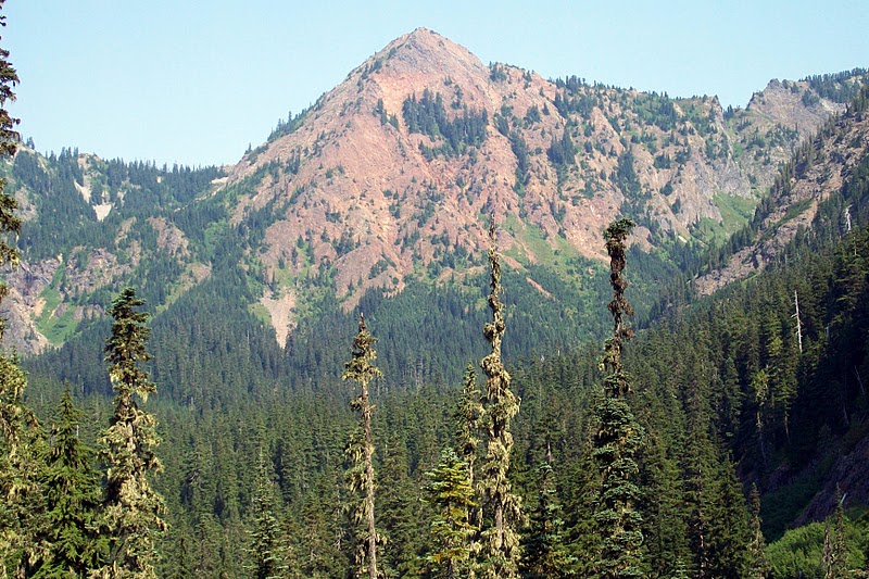
Red Mountain and Red Pass to its left

After the very late onset of the summer season this year, the pacific northwest has experienced a consistently beautiful sunny  weather over last few weeks. In order to take full advantage of this blessing, I have abandoned my preference for  a couple weeks to recoup from an arduous hiking trip, and in stead, started hiking every week I can get away. The Red Mountain can be seen from the I-90 highway at Snoqualmie Pass and has always fascinates me when I see it. So I set out for the Red Pass, which is a saddle between Red Mountain and Lundin Peak, over which the trail proceeds farther North down to the Middle Fork of Snoqualmie River valley.


Guye Peak and Snoqualmie Mtn viewed from PCT

The trail starts at an elevation of 3000 ft at the Pacific Crest Trail (PCT) trail head at the Snoqualmie Pass just off of I-90 exit number 52 for East Summitt. The PCT runs from Mexico in the South all the way to Canada in the North along the crest of Cascade Mountain Range. This trail is a very popular hiking destination and appears to be well maintained. I headed North on a gently ascending trail for 2.5 miles after which at 4000 ft elevation, the Commonwealth Basin Trail starts leading to the Red Pass. 

Red Lake

Beyond the junction, the trail gradually descends by about 200 ft and ascends back to 4000 ft over about one and a quarter miles. I noticed the old Commonwealth Basin trail that has been abandoned and marked so. After this segment with relatively mild gradient, the trail climbs up rapidly to 4900 ft over numerous switchbacks in about three quarter of a mile. At this point there is a short detour the Red Lake at the foot of Lundin Peak. I took a a short detour to have a look. It appears as a serene water body with steep mountain slopes almost on three of its four sides.

Wild flowers

Beyond the Red Lake, the trail embraces the huge rockfall area with lose rocks on the west face of Red Mountain. After another half mile, I finally arrived at Red Pass at an elevation 5300 ft. Immediately to the north is a precipice. A ridge line on either side runs to the Red Mountain and Lundin Peak while the trail first runs West and then continues North descending on the east face of Lundin Peak. The location provides spectacular view of the 6554 ft high Mount Thompson. I soaked up the views all around and took pictures while eating my lunch. 

Mount Thomson viewed from Red Pass

On my way back, I looked for a trail for getting to the Red Mountain summit. The large rock fall area with small sized rocks seemd to be a dangerous option, for it seems a pretty unstable route and you would not want anyone above you dislodging rocks that are precariously in place. The most obvious possible trail to the summit seemed to be a blocked trail near the detour to the Red Lake. To get to the summit, I would want with me someone who had made it before. That would be something for the future. 

Loose rocks on Red Mountain west wall


Saturday, September 3, 2011

Guye Peak and Cave Ridge Trail

Rock climbers on the farthest peak

Trail Distance: 8 miles
Cummulative Elevation Gain: 3500 ft

Wild flowers
After the aborted attempt to hike Guye Peak last week, today was another opportunity to complete the intended hike with an excellent clear sunny sky. I am aware of an alternate trail that starts off from the Pacific Crest Trail (PCT) trail head about a mile away. This alternate trail however is not shown on the map. So with a mind to do a bonus of Cave Ridge trail today, I trusted the mapped trail I already treaded, so as to avoid any possibility of getting lost and losing time. So I started off the same Alpental trail head and followed the same trail onto the point whereupon we quit in the previous hike, and then continued to the Guye Peak. The new section that I have covered today is not much different in gradient, but more open and mostly on rocky surface. I also noticed another trail coming up from the eastern face. This is perhaps the trail that starts at the Pacific Crest Trail (PCT) trail head.

Bee on flower

 There are in fact three peaks at Guye Peak. I settled on the first and started taking pictures of the 360 degrees of views. The cars at the parking lot at the trail head appeared tiny from that height of about 2000 ft.

Looking down at the parking lot

All peaks and ridges in the surroundings were clearly visible on the clear sunny day. While munching onf my lunch pack, I was joined at the narrow top by a group of three young guys. Together, we could see two other guys atop the third peak. They reached there by rock-climbing and then proceeding towards the peak we were perched on.

Me at Guye Peak

On my return from Guye Peak, I picked up the the Cave Ridge trail as planned earlier. This is a moderately steep trail. I saw several small. yet deep pockets of packed snows. But the trail was free of snow except for a very short stretch of about 6 ft. This seems to be a less frequented trail with abundance of wild flowers around. It also provides a very close up view of the Snoqualmie Mountain to the North.

Guye Peak and Mount Rainier from Cave Ridge trail


Soon I reached the the cave,  which is located at a small and relatively flat area. The cave is in fact like a hole into the ground. From the conversation with the other three guys on Guy Peak, I learned that the cave is very narrow and at the end you would crawl forward to get to the edge of a precipice.

Information Board at cave entrance

There is an information board positioned by the cave entrance. As per the information, being alone and lacking in appropriate gadgets, I decided not to venture into the cave. In stead, I proceeded onward to the nearby hilltop for some more views and returned after spending about 15 minutes up there.

Mount Thomson

I noticed even more trails coming up from the eastern face of the mountain. So I can see a few alternative options for a future hike with more company - to use the trails from the PCT trail head, explore the cave and scale the other two peaks of Guye Peak - hopefully on one single arduous trip?

Kendall Katwalk on PCT

Saturday, August 1, 2009

Kendall Katwalk

Saturday, August 1st, 2009
Cumulative Elevation gain 2700 ft
Trail length: 5.5 miles one way
Time taken: 2hr 45 minutes s on way up and 2 hr 30 on way down.
Level of difficulty: Difficult
From 20090801 Hiking Kendall Katwalk
Kendall Katwalk is a segment of the Pacific Crest Trail that extends from Mexico all the way to Canada. The access point to the trail is located at the Snoqualmie Pass on the I-90 Interstate Highway. It is undoubtedly the most scenic trail I have hiked so far in the short history of my hiking undertakings. The experience was definitely heightened by the company of my friend Rajib.

The aspect that struck me during the trip was that there were more back-packers on this trail than folks coming for a day-hike. We met several parties who were either going on for or returning from an overnight backpacking trip. Most camped by side of lakes further to the north of the Katwalk. One pair was actually hiking for the seventh day since they started at the Stevens Pass on US Highway 2.

The Katwalk itself is a short segment of the ridge line between the Kendall Mountain and the Red Mountain, a mountain literally red-colored in its appearance. The ridge walls fall sharply on either side of the trail which is about 5 feet wide at that segment. About a mile before reaching the Katwalk, the trail emerges from the forests and the steep wall on the West side of the Kendall Mountain as well as a skyline of the mountain tops on the west side starts coming into view. We also captured a nice glimpse of the Mount Rainier.
From 20090801 Hiking Kendall Katwalk
It would be a turning point however, for those who have vertigo - so steep are the slopes. The trail here is narrow and can be dangerous in presence of snow. We encountered now snow though. At the Katwalk, the views are available on both East and West directions.
From 20090801 Hiking Kendall Katwalk
A mile or so beyond the Katwalk exist two lakes on either side of the trail - the Alaska lake and the Gravel Lake. Many hikers carry on till reaching there. We decided to call it a day at the Katwalk with the intention of returning in future to continue hiking to the lakes on that trip. On our way back, we heard the very loud and long calls of a marmot that was sitting on top of a big rock situated way above the trail where the trail passes through a rockfall.
From 20090801 Hiking Kendall Katwalk
More Pictures