Trail Distance: 1.5 miles round trip
Elevation Difference: 200 ft.
“It is good to have an end to journey toward; but it is the journey that matters, in the end”.
 |
| Seattle waterfront as viewed from the ferry |
This proverb can not be truer in case of the short hike to Cape Flattery: in terms of the the travel to get to the trail head as the journey that includes a ferry ride from Seattle to Bainbridge Island, followed by 174 miles of driving mostly on the Strait of Juan de Fuca Scenic Byway, though Cape Flattery itself being the home to the Makah People, and the most northwestern tip of the continental United States, has its own cultural, geographical,and associated historical significance worthy of a an attractive tourist destination.
 |
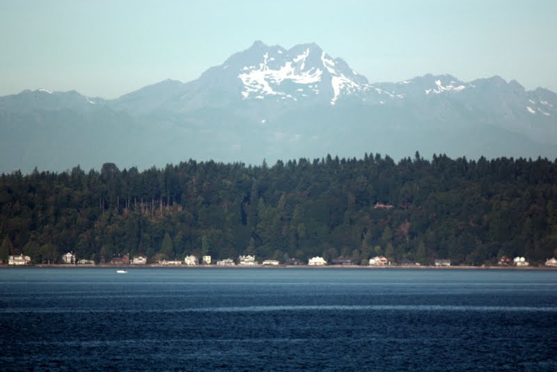
| Olympic Peninsula visible above Bainbridge Island across the Puget Sound |
It was one of those infrequent events when Minakshi would accompany me for a hike. In the past together we undertook a couple of much more arduous hiking trips to Goat Peak (5 miles/1500 ft) and Poo Poo Point (7.4 miles 1650 ft). On this occasion, I suspect that the lure going on a long drive was stronger than the appeal of associated hike to the final destination.
 |
| Us on the ferry |
To begin with, we drove about 25 miles from home to the Seattle ferry terminal and boarded a ride across Puget Sound to Bainbridge Island. This 45 minute long ride provides unmatched views of both downtown Seattle to East as well as of the Olympic Peninsula to the West. Bainbridge Island is connected to the Olympic Peninsula on the West by the famous Hood Canal floating bridge. Our first stop on the peninsula was at Sequim to fill up the gas tank and to eat lunch. We drove by the Port Angeles town to get onto state highway 112 which is designated as the Strait of Juan De Fuca Scenic Byway. Part of this road runs by the shore line of the strait which connects Pacific ocean with the Puget Sound and also serves as a geographical and political boundary between the Unites States and Canada. To the north of the strait lies the Vancouver Island of the British Columbia Province of Canada.
 |
| Strait of Juan De Fuca |
The drive was slow and tortuous at times but scenic never the less. Yet I must warn that unless you enjoy driving as much as I do, you may want to take the alternate route by highway 101. We passed Clallam Bay, Seiku, and then Neah Bay, the home of the Makah Tribe on the way, to finally reach trail head for Cape Flattery, about is 7 miles beyond Neah Bay.
 |
| Tatoosh Island |
The trail runs under old growh forest gradually descending and finally ending at a wooden platform perched 250 ft above the sea level. There are other such platforms nearby. All the platform provides excellent views out to Pacific Ocean, the nearby coast line and the Tatoosh Island, which is actually the real northwest tip of the Unites State.
 |
| Pacific coast line at Cape Flattery |
On our return trip, we detoured by highway 113/101 that provides about 8 mile long scenic segment along Lake Crescent. Then we stopped by Port Angeles to have a snack while soaking up the ambiance of the waterside afternoon with a light breeze on that otherwise warm day. Besides being a port of entry by ferry from Victoria, BC in Canada, Port Angeles also provides access to Hurricane Ridge, a very popular recreational destination in the Olympic Peninsula National Forest.
 |
| On the Ediz Hook |
By the time we got to the Bainbridge Island ferry terminal to catch the Seattle ferry, darkness had settled in all around, and provided an excellent nighttime view of the lit up Seattle skyline. Unfortunately, the combination of vibration of the ferry and a strong and extremely cold breeze out on the dock prevented me from capturing any worthwhile picture to share.


No comments:
Post a Comment