Sunday, July 31, 2011

Snoqualmie Mountain

Sunday, July 31, 2011

Distance: 6 miles out and back
Elevation Gain: 3278 ft
Highest Elevation: 6178 ft

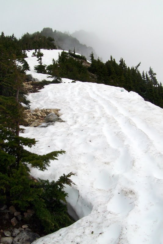
Looking up snow clad ridge
Anyone who has driven on Interstate 90 highway past Snoquamie Pass can not miss the imposing view of  Snoqualmie Mountain sitting just to the north of the hairpin bend the highway takes at summit and beyond the nearby Guye Peak. Whenever I see it, I use to get an urge to one day scaling this peak.Despite the clouded sky, this was the day I walked on that trail. However, I found only one review of recent hike reported. This hiker picked up a wrong trail while climbing through an elevation of 500 ft before he realized the mistake. This report forewarned me of what it might be like if I am not paying attention on the trail.
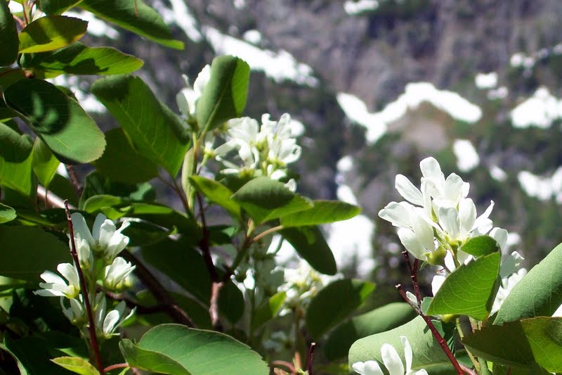
Wild flowers!
Unfortunately, in the haste of getting there and back on time for dinner with my neighbors Aryan and Julie to celebrate the birth of their newborn daughter Rayena, I forgot to pack my Annual Northwest Forest Pass. This pass permits hikers to park inside any national forests in the states of Washington and Oregon. The Alpental trail head is a part of Mount Baker-Snoqualmie Nationa Forest.Since the pass I already have would cover me through end of October, I stoppled by the Snoqualmie Pass Visitor Center and picked up a day pass just for the day today. I also looked for information on condition of the trail to my destination but there was not much to be had as not many seems to have gone there recently and reported.

Colorful new blooms

The unmarked trail starts just south off of more popular and well marked Snow Lake trail. The trick to get to the correct trail is branching off onto a precariously unassuming side trail. Once after crossing a short stretch of colorful meadow, the trail climbs relentlessly over three quarter miles or so through a forested area and through an elevation of 1100 ft at the end of which there is a fork, the other leg leading to Guye Peak. There is a marker with directions of the two trails posted high above on a tree trunk. There can not be any mistake at this point about where the trail is heading.

Directions!
After a short breather that leads across a stream with  waterfalls on either sides, the trail resumes the relentless climb through thik forests for next half a mile. I encountered the first snow at an elevation of about 4800 ft inside that forested stretch. Pretty soon, the trail climbed onto a ridge with pebbles and dry ground where the forest gave way to short shrubs. As the trail gained more elevation, I started walking on large sheets of snow. Hereafter, the trail continues on the ridge all the way to the summit, passing on and off snow covers. There is supposed to be great views from the ridge on a sunny day.. But I was surrounded by so much of clouds and passing mists that I could catch only fleeting glimpses of nearby peaks and mountains. On trips to peaks, I always hope to catch sight of the distant Mount Rainier but this was not my day for that privilege.
 

I had my lunch of garden fresh cherry tomatoes, and cucumber, picked only this morning, and a home made sandwich while enjoying the serenity of my surroundings with ragged mountain tops just nearby peaking through dense mists passing by. I packed up a little while later and while heading back, met just one other hiker, and elderly gentleman going up that mountain. I vow to return another day to get my share of views from Snoqualmie Mountain!

Guye Peak and a piece of I-90 peeking through mists

Sunday, July 24, 2011

Source Lake and Snow Lake

The Source Lake from above
 Sunday,, July 24, 2011
Distance: 5 Miles Round trip
Cummulative Elevation Gain: 1500 ft

The weather was nice. Yet because of the late onset of summer this year, the snow has not melted at most of the usual destinations. Even at the Snoqualmie Pass area, a lot of snow was reported by other hikers earlier in the week. My friend Mrinal accompanied me on this hike. Mrinal has not hiked on snow before. As a safety precaution, we decided to hike the snow lake trail, which is a popular one with a lot other people around, at the same time, not too far off for a Sunday hike (Can not get too tired - got to get back to work tomorrow :-)). Another great reason to hike these areas now is the blooming wild flowers.

Beautiful mountainside and the trail
We were at the trail head at around 10.30 am. The very large parking area was about half full. There was a forest ranger hiking alongside and answering questions about trail conditions out in the wild. We learned from her  that the the north facing trail section that descends down to the Snow Lake beyond the saddle at 2.1 miles and 4400 ft elevation was still snow covered and almost un-surpassable using fair weather hiking gears only. So at the fork after 1.5 miles and 3700 ft elevation, we went on to explore the Source Lake view point. The trail actually runs much higher on the north flank of the mountain side of the valley. It is the Source Lake where the South Fork of the Snoqualmie river originates and after flowing over a few miles joins with the Middle and the North Forks near North Bend city. 

Magnificent wild flowers blooming
Part of the trail length leading to the Source Lake view point was snow covered. My fried was excited at the opportunity to walk on the snow. We were careful not to miss a step or put in a misstep. We saw two pairs of foot trails out on the snow covered southern flank of the stream and wondering if any hikers went hiking off trails. Then at the view point we met two women who were apparently lost and made those foot prints looking for a way to the snow lake. I told them about the fork about half mile back before settling down there to eat our snack and head back a little later.
  
Mrinal and I with Snow Lake In the backgrond

 Back at the fork, we now made it towards the Snow Lake. This trail segment was totally covered with snow. There were a lot of people out there. But most of them hung around at the ridge at 4400 ft. There was great view of the Lake down below providing some beautiful picture opportunities. However,  the trail beyond seemed to be buried in at least kneed deep snow just like we learned earlier from the forest ranger. So Mrinal and I agreed that this was our final destination and turned around for the trail head.

Hikers enjoying views of Snow Lake and beyond


Sunday, July 17, 2011

Kachess Beacon Trail

Distance 2 miles out and 3 miles back
Elevation Gain: 2200 ft

The Beacon

Why this trail today? Because it is highlighted as the "Hike Of The Week" at the WTA site - supposed to be free of snow while the wild flowers are blooming, both of which actually turned out to be true. In consideration of Amlan - my hiking companion today who has not hiked much before, I was also looking for a trail that would not be too arduous, yet would have a rewarding experience at the end. This trail fitted the bill on both counts.  Initially I was reluctant to travel 60 miles to get to the trail head. However,the weather forecast for areas/trails closer to home included thunder showers. So I thought we would have lesser possibility of getting rained on in the rain shadow area to the East of the Snoqualmie Pass. So that is where we went and were able to enjoy a rain-free hike.

Colorful Meadow

We saw just one car at the trail head parking lot when we reached there around 9:20 AM. As soon as we got out of the car, a host mosquitoes descended upon us. So without lingering on, we immediately put on our hiking boots, changed to long trousers and charged on. The mosquitoes followed us in forested segments of the trail all the way through to the top, but their number gradually decreased as we ascended the the mountain. This mosquito incident has taught me a lesson to add another hiking essential to my arsenal - some kind of mosquito repellent.

Wild Flowers

After climbing through an elevation of about 900 ft over one mile distance,  we met a couple of hikers returning who alerted us about the loop - basically consisting of two segments: the regular trail two miles long thereafter and a steeper alternate trail of one mile distance, both climbing through the remaining height of 1300 ft. This alternate trail forked just a few hundred feet beyond where we met those other hikers. We reasoned we would do the shorter ascend so the longer descend would be easy on our knees. Though climbing the 1300 feet over a mere 1 mile stretch did turn out to be pretty tough, yet it rewarded us with excellent views of both distant clouds and mountains as well as of wildflowers on the nearby hill slopes .

Distant Mountains

The views from top would be better on a cloud free day yet still satisfying in the cloudy weather today. My regret is that we were denied a sight of the Mount Rainier. But all other relatively closer mountain ranges with snow-clad white peaks and both the Easton and Kachess lakes below were great treats to our eyes. At least I am hoping it wasn't disappointing to Amlan.

Me and Amlan at the Beacon

  We met one other hiker at the top who hiked from a different trail head. As we were leaving after spending three quarters of an hour, more hikers arrived. We met many more on our way back - this time on the regular trail. This precisely was the reason we were here early - to beat the crowd. I expected that "Hike of the Week" report at the  WTA site to nudge a big crowd to this trail today, and it actually so happened.

More Wildflowers

Saturday, July 2, 2011

Revisiting Granite Mountain

Saturday, July 2, 2011
Distance: 8.6 Miles Round trip
Elevation Gain: 3800 ft


It was the long weekend of 4th of July with the Monday being the holiday. Excellent weather was in forecast. And I have not gone hiking for a while (not counting a short trip to Poo Poo Point the previous weekend). So I wanted to make the most of this first nice day of the Summer by visiting some place good. I thought about Granite Mountain Lookout which I visited two years ago. There were other options at the trail head of hiking to several lakes which falls under the category of "Family Friendly". But that day I was  inclined to go for a more rigorous workout. Granite Mountain Trail at 8 miles round trip and 3800 elevation gain provided just that. 

As expected of a long holiday weekend with such excellent weather condition, the trail head barely had any parking spot left. I was in fact lucky to arrive late around 1 pm by which time a couple of the early hikers returned already and left to open up a space for me. You would need a NW Forest Parking Pass to park at this trail head and half miles beyond. I noticed some parked outside of that jurisdiction so I presumed the included some casual hiking enthusiasts as well.

Midway through the trail length, I realized that the fact that hiking late in the day makes it more arduous compared to starting early on the day when the air is cooler and feels so much more soothing. About the same time I caught up company with a group of two guys and two gals. The guys one of the couple seemed to be frequent visitors to these mountains while the other two, I learnt has moved to the Northwest recently and having their first taste of mountain hiking in the Snoqualmie pass area. We continued together thereafter on the snow clad segment of the trail until reaching the Lookout at the top. 


Unlike my last visit to this lookout in 2009, this time it was accessible because Brad who is a volunteer ranger serving the United States Forest Service (USFS) was manning the lookout for the weekend. He signs up for this service because he loves nature and likes to "Entertain" hikers coming out there. He stays overnight during the weekend. Actually looking out for fires is the other prime responsibility for the rangers. Brad's daughter is also a hiking enthusiast, who also spent the previous night in lookout and at the moment was out on a hike to the Talapus Lake located at the western precipice of the Granite Mountain peak. She was expected to be back at the lookout later that afternoon. 

I realized that my outlook about hiking/climbing has changed over last few years. I used to keep time, trying to get to the top and back as fast as I could. Somehow I do not feel that urge anymore. In fact, I am starting to take it slow and enjoying the journey more than just getting to the destination. How the solitude of nature makes it easier to get a different perspective! Or are the passing years of life the reason for that?

More Pictures